Regional probabilistic seismic hazard assessment in Bangladesh
Azari Sisi, Aida
Kaiser, Diethelm
Spies, Thomas
Schlittenhardt, Jörg
Konferenzbeitrag
Englisch
Azari Sisi, Aida; Kaiser, Diethelm; Spies, Thomas; Schlittenhardt, Jörg, 2021: Regional probabilistic seismic hazard assessment in Bangladesh. DOI: 10.23689/fidgeo-3943.
 |
Dokument öffnen: |
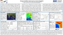
This presentation summarizes input data, procedures and results of probabilistic seismic hazard assessment (PSHA) in Bangladesh in the framework of the project ‘Geo information for Urban Planning and Adaptation to Climate Change’. It is a cooperation of the Geological Survey of Bangladesh (GSB) and the Federal Institute for Geosciences and Natural Resources (BGR) of Germany. The main aim of the project is to provide city planners with “Ground Suitability Maps”, which display different geo-factors. Seismic hazard is one of the geo-factors that contributes to these maps. For the derivation of “Ground Suitability Maps”, the influence of the local underground conditions will be taken into account additionally. A major part of Bangladesh is located in earthquake prone regions due to active tectonics. The Indian plate moves north-eastward towards the Eurasian plate at a velocity of about 6 cm/year. This motion leads to thrusting to the north (Himalaya) and to subduction to the east together with strike-slip mechanism. The thrusting and subduction processes have caused large historical earthquakes even inside Bangladesh (e.g. 1885 Bengal Earthquake M7 and 1918 Srimangal Earthquake M7.6). Therefore, it is crucial to assess seismic hazard in urban planning in Bangladesh. The input databases were compiled from the literature, reviewed and evaluated in this study. These are earthquake catalogs, the distribution of active faults and ground motion prediction equations. The most consistent and reliable databases were selected to be used in PSHA. The data of the earthquake catalog were declustered to eliminate the duplicated events, aftershocks and foreshocks. The spatial distribution of areal seismic sources was characterized using the distributions of earthquakes in the catalog and active faults. The completeness analysis of the earthquake catalog was performed and the Gutenberg-Richter magnitude recurrence distribution was derived for each seismic source. The results of PSHA are presented in the form of peak ground acceleration (PGA) maps with 10% exceedance probability in 50 years. As usual in regional PSHA, the results were compiled assuming bedrock as underground condition (so-called engineering bedrock with shear velocity of Vs30≥760 m/s). The northern and eastern parts of Bangladesh show the highest seismic hazard with PGA around 0.4 g with 10% exceedance probability in 50 years. This observation was expected because of the active tectonics in these parts.
