Induced microseismicity due to mine flooding - Observation, characterisation and relation to mine water rise in the eastern Ruhr area
Rische, Martina
Fischer, Kasper D.
Konferenzbeitrag
Englisch
Förderer: Bundesministerium für Bildung und Forschung
Rische, Martina; Fischer, Kasper D.; Friederich, Wolfgang, 2022: Induced microseismicity due to mine flooding - Observation, characterisation and relation to mine water rise in the eastern Ruhr area. DOI: https://doi.org/10.23689/fidgeo-5401.
 |
Dokument öffnen: |
The Floodrisk project takes a muti- and interdisciplinary look on the effects of the rise in mine water level in abandoned coal mine regions in Germany. Such effects are heterogeneous ground uplift, stress changes due to the pore pressure changes and the reactivation potential of faults. One of the most directly measurable effects is the induced seismicity. It is known from previous studies that the flooding of old mines can lead to a renewed increase in induced microseismicity in these regions.
We focused on the observation of the eastern Ruhr area and investigate in detail the relationship between mine water rise and induced seismicity in the Haus Aden dewatering area.
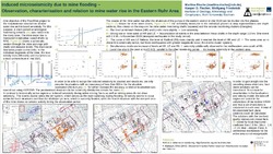
For this purpose, we operate a network of up to 30 short period seismic stations in the region of the former "Bergwerk Ost" colliery, which had the highest seismicity rate in the Ruhr area during active mining. Continuous monitoring of seismicity and mine water levels is available for this region from the active mining phase, through the post-mining phase to flooding.
Since the beginning of the flooding, more than 20000 onsets were picked and over 1700 induced events were localised in a magnitude range from -0.7 up to 2.6 MLv. For some larger events, focal mechanisms could be determined.
The spatial distribution of hypocentres is divided into two areas, with few events in the central study area and over 95% of earthquakes in its eastern part. Many of these events are spatially clustered and some show quite high waveform similarity. This allows relative localisation to increase the accuracy of the location. Comparing the old galleries,which today serve as the main underground waterways, with the localisations from the relative localisation, strong correlations can be seen.
The measured temporal trend of the mine water level, after pumps were shut down in mid-2019, shows a strong correlation with the temporal evolution of the observed micro seismicity. In the first months after the pumps are switched off, the water levels at the observation points rise only slowly and isolated microseismic events occur again. In November 2019, the rise in water levels doubled and at the same time, the strongest induced event in the measurement period was recorded with a magnitude of 2.6 MLv. In the years 2020, 2021 66 and 58 events >= MLv 1 were observed, respectively. In contrast to this number only 2- 9 events >= MLv 1 per year were observed in the post-minig phase before flooding.
Statistik:
ZugriffsstatistikSammlung:
 CC BY 4.0
