Suche
Anzeige der Dokumente 1-10 von 55
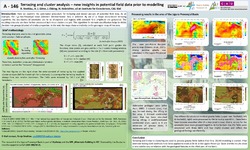
Terracing and cluster analysis – new insights in potential field data prior to modelling
;  ; ; (2022)
; ; (2022)
Geological maps are complex to produce through intensive and expensive field studies. Comparisons of geophysical data with geological conditions are difficult and often only qualitatively possible. The following work ...
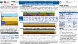
Computational Modelling of Coupled Heat Transport between the Heterogeneous Earth and an Overlying Ice Sheet
Bodenburg, Sascha; ; Blachut, Wojciech; ; (2021)
; Blachut, Wojciech; ; (2021)
Due to a complex interplay between the Earth and overlying ice sheets, a large variety of subglacial landforms developed. One example is the in the North German Basin widely spread phenomenon of tunnel valleys. An observed ...
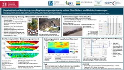
Geoelektrisches Monitoring eines Bewässerungsexperiments mittels Oberflächen- und Bohrlochmessungen
; ; ; ; ; (2022)
; ; ; ; (2022)
In Folge des Klimawandels kommt es in Mitteleuropa vermehrt zu Dürreperioden und Austrocknung von Böden. Indem tief- und flachwurzelnde Nutzpflanzen sinnvoll kombiniert werden, kann die Verfügbarkeit von Wasser teils auch ...
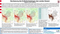
Neufassung des Erdbebenkataloges des Landes Hessen
(2022)
Der Hessische Erdbebenkatalog ist eine Zusammenstellung historischer und aktueller Informationen zu Erdbeben in Hessen und direkter Umgebung von Hessen. Er wird vom Hessischen Erdbebendienst geführt und regelmäßig aktualisiert. ...
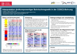
Interpretation dreikomponentiger Bohrlochmagnetik in der COSC2-Bohrung
; ; ; (2022)
Das Ziel des COSC-2 (Collisonal Orogeny in the Scandinavian Caledonides) Projektes ist es, die Entstehungsprozesse der Skanden zu untersuchen. Hierfür sind Kenntnisse über die Deformationen / Faltungsprozesse von großer ...
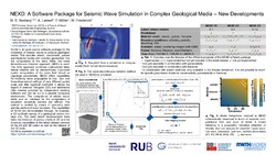
NEXD: A Software Package for Seismic Wave Simulation in Complex Geological Media – New Developments
; ; ; (2021)
NEXD is an open source software package for the simulation of seismic waves in complex geological media.
This includes elastic, viscoelastic, porous and fractured media with complex geometries. For the computation
of the ...
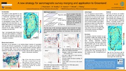
A new strategy for aeromagnetic survey merging and application to Greenland
; ; ; ; (2022)
; ; ; (2022)
Aeromagnetic surveys help us to learn about geology. To achieve good coverage, surveys need to be merged. However, conventional methods introduce long-wavelength bias and cannot handle the individual survey quality.
We ...
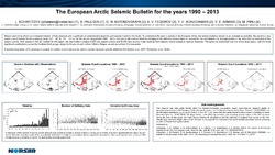
The European Arctic Seismic Bulletin for the years 1990 – 2013
; ; ; ; ; ; (2022)
Recent years have shown an increased interest in Polar research and in particular in understanding tectonics and seismic hazard in the Arctic. To understand the seismic activity in the European Arctic, the seismic bulletins ...
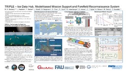
TRIPLE – Ice Data Hub, Model-based Mission Support and Forefield Reconnaissance System
; ; ; ; ; ; ; ; ; ; ; ; (2021)
The ocean worlds of our Solar System, like Saturn's moon Enceladus and Jupiter's moon Europa are covered with ice. Recently, these icy moons gained further scientific interest, as they are attributed some potential to ...
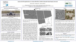
Large-scale UAV magnetometryon a former World War II airfield at Ganacker(Lower Bavaria, Germany)
; ; (2022)
In the last few years, several Unmanned Aerial Vehicle (UAV) based magnetometer systems have been tested for archaeological prospection. Due to their higher sensitivity, scalar magnetometers have been preferred as test ...
