Detecting very slow natural ground motion in Schleswig-Holstein from radar satellite data
Hoogestraat, Dieter
Sudhaus, Henriette
Konferenzbeitrag
Englisch
Hoogestraat, Dieter; Sudhaus, Henriette; Omlin, Andreas, 2021: Detecting very slow natural ground motion in Schleswig-Holstein from radar satellite data. DOI: 10.23689/fidgeo-3949.
 |
Dokument öffnen: |
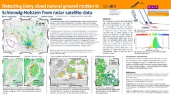
The near-surface geology of northern Germany is characterized by glacial deposits, deformed by rising Permian and Upper Triassic salt structures. Ground motions potentially associated with salt tectonic processes are very slow and are superimposed by signals of e.g. hydrological and anthropogenic sources. To measure them requires the detection of motion rates in the range of a few millimeters per year with sufficient spatial coverage. For large areas little is known about the rates and the characteristics of ground motions, even though they directly affect anthropogenic infrastructure and could have an impact on the future use of the underground for storage purposes or the exploitation of geothermal energy.
To measure ground motion, we use radar interferometric time series data provided by the German Aerospace Center and the Federal Institute for Geosciences and Natural Resources' Ground motion service. These data are based on Synthetic Aperture Radar images acquired by ESA's ERS and Sentinel satellites. Time-series analyses are possible for temporally stable backscattering objects (persistent scatterers) on the ground. Generally, this results in spatially dense observations over built-up areas and sparse observations over rural areas.
We use a set of geostatistical methods to analyze these time series data. We detect signals of large-scale surface-deforming processes such as the subsidence of the marshes. We see small-scale signals like the swelling of Permian anhydrite at the Segeberger "Kalkberg". And we can observe subsidence processes over the historic town of Lübeck. Our work extends the area of application of the PS-InSAR technique from areas with high motion rates to regions with particular low motion rates. We discuss methods that can be used to link ERS data to the Sentinel-1 data, in particular, to separate long-term motion processes from short-term effects. We are working on techniques that shall help to decompose different signal sources. Finally, we aim to prepare a set of tools, that can be used by the community.
