Suche
Anzeige der Dokumente 1-10 von 77
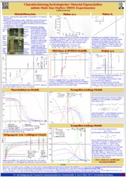
Charakterisierung hydrologischer Material-Eigenschaften mittels Multi Step Outflow (MSO) Experimenten
(2012-03-05)
Die Kenntnis hydrologischer Eigenschaften ist essentiell für das Grundwassermanagement. Im Rahmen eines Projektes zur Verknüpfung mit elektrischen Eigenschaften, welche nicht-invasiv bestimmbar sind (Spektrale Induzierte ...
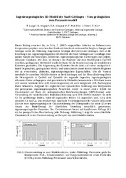
Ingenieurgeologisches 3D-Modell der Stadt Göttingen - Vom geologischen zum Parametermodell
Khojasteh, Enayat R.; Lange, Torsten;  ; Ptak-Fix, Thomas; Fritz, Joachim; Nix, Thomas (2008)
; Ptak-Fix, Thomas; Fritz, Joachim; Nix, Thomas (2008)
Dieser Beitrag erweitert die, in Fritz, J. (2007) vorgestellten Arbeiten im Rahmen eines Kooperationsprojektes zwischen dem Niedersächsischen Landesamt für Bergbau, Energie und Geologie sowie der Abteilung Angewandte ...
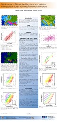
Relationships to Estimate the Magnitude Ms of Historical Earthquakes in Europe from Macroseismic Observations
; Gutdeutsch, Rolf; Jentzsch, Gerhard (2002)
We develop empirical relationships between the surface wave magnitude MS and macroseismic data, i.e. the epicentral intensity I0, isoseismal radii R(I) of different intensities I and the focal depth h. The basis of this ...
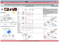
Close-range sensing workflows in Structural Geology based on open-source/open access solutions
; (2018-08-24)
In Structural Geology, many projects start with intensive field-based data acquisition campaigns, which might be performed in quite different types of natural or artificial outcrops. For some years, this field work has ...
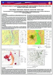
GIS-based analysis of a geotechnical-geological 3D model of periglacial Quaternary rocks in the southern Leine valley, Lower Saxony
; Sauter, Martin; Nix, Thomas; Fritz, Joachim; Lange, Torsten (2014)
Geometric 3D models are a very efficient tool to visualize geological units and structural features that have been presented before just in two dimensions on maps or cross-sections.
Most of the information of 3D models ...
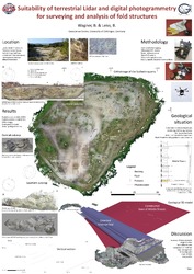
Suitability of terrestrial Lidar and digital photogrammetry for surveying and analysis of fold structures
; (
Quantitative fold structure analyses at different scales are essential for deducing deformation mechanisms and the reconstruction of the deformation history of orogens. However, not only the field surveying of fold structures, ...
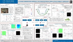
An Image Segmentation Approach for the Detection of Small-scale Magnetic Anomalies
; ; ; (2022)
Due to the still enormous burden of unexploded ordnance (UXO) in the subsurface worldwide, the safe recovery of a wide variety of buried weapons and ammunition requires efficient and reliable detection methods. Using a ...

The seismological signature of cyclonic storms through the ears of a sensor array
; ; (2021)
Under certain conditions, ocean surface gravity waves (SGW) interact with the seafloor underneath to trigger
relatively faint but measurable seismic waves known as ocean microseisms. Cyclonic storms (e.g.
hurricanes, ...
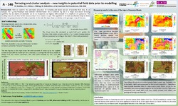
Terracing and cluster analysis – new insights in potential field data prior to modelling
; ; ; (2022)
; ; (2022)
Geological maps are complex to produce through intensive and expensive field studies. Comparisons of geophysical data with geological conditions are difficult and often only qualitatively possible. The following work ...
Computational Modelling of Coupled Heat Transport between the Heterogeneous Earth and an Overlying Ice Sheet
Bodenburg, Sascha; ; Blachut, Wojciech; ; (2021)
; Blachut, Wojciech; ; (2021)
Due to a complex interplay between the Earth and overlying ice sheets, a large variety of subglacial landforms developed. One example is the in the North German Basin widely spread phenomenon of tunnel valleys. An observed ...
