Suche
Anzeige der Dokumente 51-60 von 77
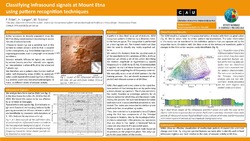
Classifying infrasound signals at Mount Etna using pattern recognition techniques
 ; ; (2021)
The ongoing activity of Mount Etna and the proximity to the nearby population requires constant monitoring. Infrasound recordings play an important role in volcanic observation because explosive activity near or above ...
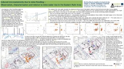
Induced microseismicity due to mine flooding - Observation, characterisation and relation to mine water rise in the eastern Ruhr area
; ; (2022)
The Floodrisk project takes a muti- and interdisciplinary look on the effects of the rise in mine water level in abandoned coal mine regions in Germany. Such effects are heterogeneous ground uplift, stress changes due to ...
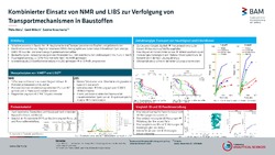
Kombinierter Einsatz von NMR und LIBS zur Verfolgung von Transportmechanismen in Baustoffen
; ; (2022)
(2022)
Das Poster präsentiert die Ergebnisse des kombinierten Einsatzes von NMR und LIBS zur Verfolgung von Feuchtigkeit und Schadionen in Baustoffen. Es wurden dazu mit zwei Sandsteine und zwei zementäre Baustoffe kapillare ...
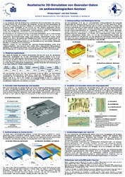
Realistische 3D-Simulation von Georadar-Daten im sedimentologischen Kontext
; (2019)
In der Geophysik stellt die Modellierung synthetischer Referenzdatensätze eine wichtige
Grundlage sowohl für die Evaluation grundlegender Schritte der Datenbearbeitung als
auch für die Entwicklung neuartiger Ansätze zur ...
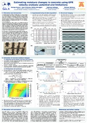
Estimating moisture changes in concrete using GPR velocity analysis: potential and limitations
; ; ; ; (2018)
Chloride-induced corrosion of steel rebars is a key problem
for the durability and safety of reinforced concrete buildings
such as bridges. Penetrating rainwater transports the
chlorides into exposed parts of these ...
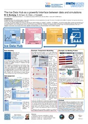
The Ice Data Hub as a powerful interface between data and simulations
; ; ; (2023)
Providing measurements for scientific simulation software often requires tedious manual preprocessing of data sets. To overcome this problem and make it easy for simulation tools to access heterogeneous data sets directly, ...
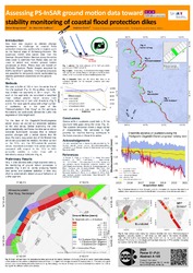
Assessing PS-InSAR ground motion data toward stability monitoring of coastal flood protection dikes
; ; (2023)
Sea level rise caused by climate change represents a challenge to coastal flood protection measures, particularly in regions such as the federal state of Schleswig-Holstein. Large parts along the North Sea coast are protected ...
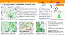
Detecting very slow natural ground motion in Schleswig-Holstein from radar satellite data
; ; (2021)
The near-surface geology of northern Germany is characterized by glacial deposits, deformed by rising Permian and Upper Triassic salt structures. Ground motions potentially associated with salt tectonic processes are very ...